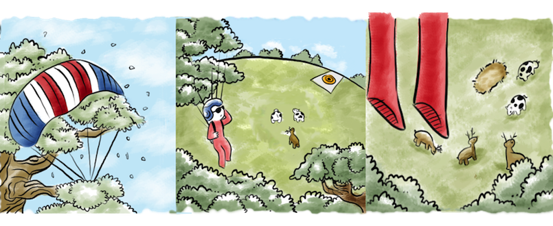
“Oh-oh, I am not going to make it back!” That is what i was thinking, hanging under canopy over the trees, and not moving anywhere. The wind on the last jump changed a lot. I clearly saw, that I barely moved forward with every 500 feet I lost. And, the dropzone was still pretty far. “Well, time for Plan B. Landing out is fun. No, really. I am a good pilot, i fly my canopy, i can find an alternative landing, plan the descent and approach.
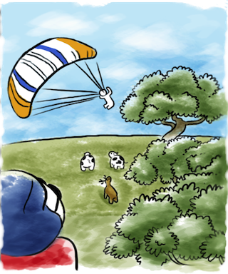
Here is nice area downwind, I will be there by at least 1000 feet, and have enough time to fly the usual pattern, to observe the landing area, and to prepare for landing. Lets see, the grass is cut, there are no wires… Wait, cows? Ughhh, its gonna be messy, cows produce a certain substance, I mean, I better stand up my landing, cause I just bought a new jumpsuit and it is still very clean. Man, the area is tight, flare, flare, shit, slip, shit. On the ground. That was fun! And these are not cows, these are elk.And my jumpsuit is red, will they question my style? Time to walk home, but here goes another jumper, and he is obviously in trouble, barely making the tree-line.
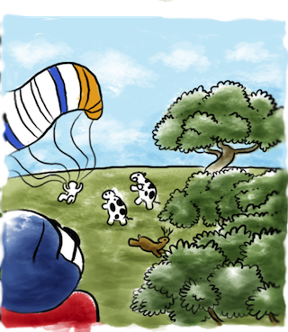
Then suddenly he makes a low turn, thumping the ground so intense, that animals are scared. I really hope he didn’t break anything, because I don’t have a phone. No, he is ok. Probably the soft ground (yes, elk poop is soft) saved him. Even if elks were unhappy with my intrusion, their grudges are satisfied now with this guy’s hard landing punishment. And I have a company for the walk back to the DZ.
This is a real story. It happened to me years back, but I still remember it. Walking back there was an angry farmer, locked gates and my camera was off. When I tell this story to skydivers, I have no problems with funny details like elk, gates, poop, and the poor guy. But if I am asked to explain what happened – then I have problems. Not because I don’t know why this happened, but mostly because it involves visualizing 3D space, with canopy descent, and a map, and a wind pushing me hard. Can i show it on the map? How do I explain why my canopy just couldn’t penetrate the wind? And why I picked the area downwind, rather than upwind. Explanation would require a lot of hand waving.
Skydiving involves lot of explanations. Telling friends about what happened. Talking about our parachutes, exits, patterns, approaches. Helping a student with a pattern. All information is in our heads. I bet i can make it visually better. Google Maps is everywhere, even in our phones.
That is why I created Spot Assist.
The first thing such an app needs is windsaloft data. That is the wind speed at every altitude, that a skydiver descends through under the parachute. NOAA has a standard format, that looks like this:

You have to learn how to decode windaloft reports But Spot Assist makes it readable. For example, this is how it looks at Gardiner, NY, home of the Skydive The Ranch drop zone.
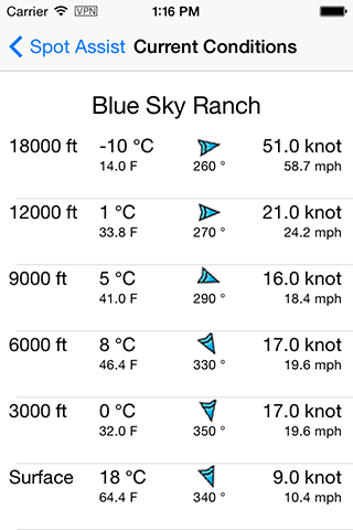
These are wind speeds and wind directions at different altitudes. This is more clear, but it is not enough. You must also have a good geographical imagination to project the data onto the map of your dropzone. Let’s put it on the map then. Like this:
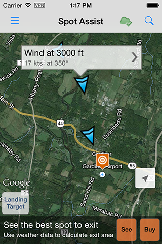
Same winds speed and directions, placed on the map. Now its’ clear, that being under canopy to the north of the DZ is fine, because the wind will help you come back. And I know exactly where it’s ok to be: north being on the other side of the road 44/55, some people often think in these terms: river, road, etc. And, in turn, if i open to the south of the DZ – that is when I have to double check the wind speed, to make sure that I can come back. Do I know how far my canopy will fly against the wind? I have an idea, I can guess, but you can’t say for sure. Can you?
Yes, you can.
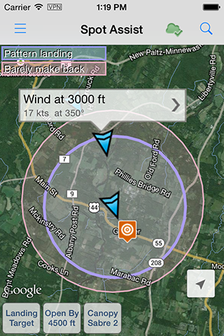
Spot Assist also has different canopies flight characteristics, and it shows the circles, which represents the range of my canopy. I see exactly how far I can be downwind, and how close I have to hold, if I happen to be upwind.
Two types of Canopy Range.
- Pattern Landing: when you plan to get to the pattern, properly fly it and land. That’s how you are supposed to plan a jump. That’s how you are supposed to land.
- Barely make it back. Strictly speaking, this one just to visually highlights a red zone. It assumes you will land from a straight in approach: no pattern, just barely make it. It’s not recommended to plan a jump like this. You may not even make it back after all. Or you will scratch the trees with your canopy, scare yourself, and swear to never do it again 🙂
Pattern.
Using the same data: wind speed, canopy glide ratio and range, Spot Assist calculates a pattern for a certain canopy. Remember the wind correction angle formula? It is used here to show the amount of crabbing, required to overcome the wind push.
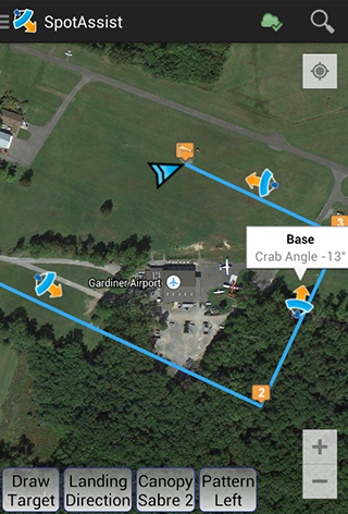
The pattern calculation can be not perfect though, the program just shows how it will look if you follow the basic recommended turning altitudes. If you notice, that the pattern is plotted over the trees, and you prefer to stay over the open field, you have the tools to make it better. You can choose the landing direction, change left or right pattern, pick downwind to base, or base to leg turning altitudes. You will see how the wind affects the pattern, how crabbing works, and how long your base leg will be.
Dropzones.
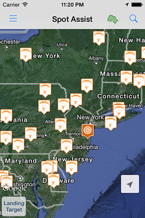
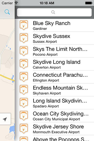
Spot Assist has a worldwide drop zones database. The data is accurate for some drop zones, and a little off for others. Every Spot Assist version improves it, and it is an ongoing process. You can change your home drop zone location: just press, hold and drag the target on the map. Or create your own new drop zone. Rest assured, the data will be shared to build a crowd-sourced database of drop zones all over the world.
Simulator.
This is the essence of the Spot Assist idea. If you are an instructor who often shows the pattern to students – you can simulate winds. There is an option – called simulator. The map, range circles, and a pattern look exactly the same, with one VERY important difference: you set your own winds, to demonstrate HOW and WHAT would have happened, if the winds were different. For instance, how much further the student would have to exit, and how his/her pattern would change, if the wind changed its direction or speed. This is a great tool to visually learn the effects of wind on the ground – before the jump or in ground school. It has been tested at the safety day at Skydive The Ranch, and people were just stunned. They said, it’s like a map came alive.
So what is next in Spot Assist? There are still areas to grow. Flying the canopy in deep brakes, or with rear risers. All these modes with the wind, or against the wind. Better canopy glide ratio measuring, etc. Better world weather coverage, South America, Australia, New Zealand.
Oh, and one more thing:
Spot Assist is absolutely, definitely and unconditionally not usable in free-fall or under a canopy… And that is a good thing.
For those who are interested in the parachute aerodynamics and math – here is the Flying Formula, used by Spot Assist Happy jumping and Blue Skies



2 Thoughts on “What is Spot Assist”
Comments are closed.